Do you want to stay in your home?
If the bank will not work with you, we can try to match you with an investor who may assume the mortgage note and negotiate terms that could help you stay in your home.
Tap to get started →
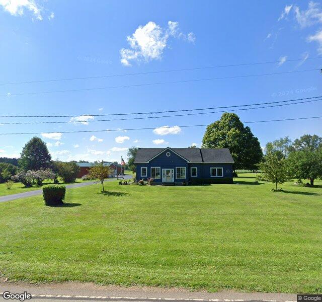
We The People News • Foreclosure Rights Notification
$712,079.68
Albion, Jackson County, MI
49 days left in the redemption window
Courtesy of wtpn.news · Protecting homeowners and advocating for your constitutional freedoms and rights.
This property appears in foreclosure-related records. Michigan homeowners may have rights during the redemption period under MCL 600.3240. This page is informational and not legal advice.
If the bank will not work with you, we can try to match you with an investor who may assume the mortgage note and negotiate terms that could help you stay in your home.
Tap to get started →
We can try to put an option together that may help in a difficult time, including support planning so your transition is organized and documented.
Tap to get started →
In some situations we can leverage redemption timing to negotiate a potential cash-for-keys agreement that helps cover moving expenses.
Tap to get started →
Free, confidential, and no-obligation. Tell us whether you are the owner or an investor and we will show the matching form.
We are not the bank or a collector · No cost · No obligation · Your info is never sold
Full published foreclosure notice text from legalnews records.
Notice of Foreclosure by Advertisement Notice is given under section 3212 of the revised judicature act of 1961, 1961 PA 236, MCL 600.3212, that the following mortgage will be foreclosed by a sale of the mortgaged premises, or some part of them, at a public auction sale to the highest bidder for cash or cashier's check at the place of holding the circuit court in Jackson County, starting promptly at 10:00 AM, on June 17, 2026. The amount due on the mortgage may be greater on the day of sale. Placing the highest bid at the sale does not automatically entitle the purchaser to free and clear ownership of the property. A potential purchaser is encouraged to contact the county register of deeds office or a title insurance company, either of which may charge a fee for this information: Name(s) of the mortgagor(s): Charles W. Center and Bonnie L. Center, husband and wife Original Mortgagee: Mortgage Electronic Registration Systems, Inc., as mortgagee, as nominee for lender and lender's successors and/or assigns Foreclosing Assignee (if any): VILLAGE CAPITAL & INVESTMENT LLC Date of Mortgage: May 1, 2024 Date of Mortgage Recording: May 31, 2024 Amount claimed due on date of notice: $712,079.68 Description of the mortgaged premises: Situated in Township of Parma, Jackson County, Michigan, and described as: Commencing on the North line of Section 7, Town 2 South, Range 3 West, Parma Township, Jackson County, Michigan, 33 rods West of North 1/4 post; thence South 10 rods; thence East 12 rods 2 feet; thence South 30 rods; thence Easterly to West line of right-of-way of L.S. and M.S. Railroad right-of-way; thence Southerly along said Westerly right-of-way line to a point 50 rods South of East and West 1/4 line; thence West 62 rods 6 links; thence North 50 rods; thence West to West 1/8 line; thence North to North 1/8 line 80 rods; thence West to West line of Section; thence North to Northwest corner of said Section; thence East to a point 4 rods East of West 1/8 line; thence South 13 rods; thence East 5 rods; thence North 13 rods to Section line; thence East on section line to beginning. Except: Commencing at a point 9 rods East of the Northwest corner of the East 1/2 of the Northwest 1/4 of Section 7, Town 2 South, Range 3 West, Parma Township, Jackson County, Michigan; thence South 11 rods; thence East 6 rods; thence North 11 rods; thence West 6 rods to the point of beginning of this exception. Also except: Commencing 4 rods East and 13 rods South of the Northwest corner of the East 1/2 of the Northwest 1/4, Section 7; thence East 5 rods; thence South 35 1/2 feet; thence West parallel with Section line 300 feet; thence North 250 feet; thence East 217 1/2 feet to Stokoe West line; thence South on Stokoe's West line 13 rods to place of beginning. Also except: A parcel of land in the East 1/2 of the Northwest fractional 1/4 of Section 7 described as follows, to wit: Commencing at a point on the North line of Section 7, 247.5 feet East of the Northwest corner of the East 1/2 of the Northwest fractional 1/4 of Section 7; thence South 181.5 feet; thence West 99.00 feet; thence South 68.5 feet; thence East 103.0 feet; thence North 250.0 feet to the North line of Section 7; and thence West 4.0 feet to the place of beginning of this exception. Also except: Land in the West 1/2 of the Northwest 1/4 of Section 7, described as follows, To wit: Commencing at the Southwest corner of the Northwest 1/4 of the Northwest fractional 1/4 of Section 7; thence North 610.5 feet along the West line of Section 7; thence Easterly 580.8 feet parallel with the South line of the Northwest 1/4 of the Northwest fractional 1/4 of Section 7 to a fence now standing, thence Southerly 610.5 feet along said fence now standing to the South line of the Northwest 1/4 of the Northwest Fractional 1/4 of Section 7, and thence Westerly fractional 1/4 of Section 7 To the place of beginning of this exception, Also except land in the West fractional 1/2 of the Northwest 1/4 of Section 7, described as Follows, to wit: Commencing on the North line of Section 7 at a point 40 rods West of the Northwest corner of the East 1/2 of the Northwest 1/4 of Section 7; thence South 650 feet; thence West 200 feet; thence North 650 feet; thence East 200 feet to the point of beginning of this exception, Also except: Beginning at a point on the North line of Section 7, distant 530 feet West of the intersection of the North line of said section and the West line of the Lake Shore and Michigan Southern Railroad; thence West 70.00 feet; thence South 215.00 feet; thence East 138.00 feet; thence North 50.00 feet; thence West 68.00 feet; thence North 165.00 feet to the place of beginning of this exception. Also except: Parcel of land situated in the Northwest 1/4 of Section 7, described as: Beginning at the Northwest corner of Section 7; thence South 00 degrees 48 minutes 40 seconds East along the West section line 742.03 feet to a point 610.5 feet North of the Southwest corner of the North 1/2 of the Northwest 1/4 section; thence East parallel to the South line of said North 1/2 of the Northwest 1/4 section, 580.80 feet; thence North 00 degrees 48 minutes 40 seconds West 90.00 feet; thence East 541.59 feet; thence North 44 degrees 53 minutes 54 seconds East 240.00 feet; thence North 00 degrees 15 minutes 29 seconds West along an old fence line and its extension 232.08 feet to a point 250 feet South of the North section line; thence West parallel to the North section line 180.50 feet; thence North 01 degree 45 minutes 53 seconds West 250.00 feet to the North section line; thence West along said North section line 1111.78 feet to the place of beginning of this exception. Also: That portion of the former railroad property which abuts the Easterly side of the above described property, described as follows: All that strip or parcel of land, being part of Section 7 and part of the West 1/2 of Sections 18 and 19, and being all of the right, title and interest of the grantor herein and to all those certain pieces of land and premises, easements, rights of way, and any other rights of any kind whatsoever appurtenant thereto or used in conjunction therewith on and along that property of the former New York Central Railroad Company (predecessor of Penn Central Corporation), described as follows: Beginning at the South line of the Northeast 1/4 of the Southwest 1/4 of said Section 19 as extended across the right-of-way of said railroad through a point in the centerline thereof at railroad valuation station 1361 + 47, the same being the Northerly sale line of the second parcel of land in the November 18, 1983 deed conveying property from said grantor to Harold Dean Hasenick, et ux, et al; thence extending in a Northerly direction along centerline of said railroad a distance of 14,096 feet, more or less, to a line being 660 feet, more or less, as measured in a Southerly direction along the centerline of said railroad from the North line of said Section 7 extended across the right-of-way of said railroad through a point in the centerline thereof at railroad valuation station 1502 + 43.3, the same being the Southerly sale line of property conveyed from George P. Baker, et al, trustees of the property of Penn Central Transportation Company, debtor, to Wilson W. Chamberlain and Caroline M. Chamberlain by deed dated December 7, 1970, and also being the place of ending which runs adjacent to the above described property. Common street address (if any): 16631 Devereaux Rd, Albion, MI 49224-9300 The redemption period shall be 6 months from the date of such sale, unless determined abandoned in accordance with MCL 600.3241a; or, if the subject real property is used for agricultural purposes as defined by MCL 600.3240(16). If the property is sold at foreclosure sale under Chapter 32 of the Revised Judicature Act of 1961, pursuant to MCL 600.3278 the borrower will be held responsible to the person who buys the property at the mortgage foreclosure sale or to the mortgage holder for damaging the property during the redemption period. Attention homeowner: If you are a military service member on active duty, if your period of active duty has concluded less than 90 days ago, or if you have been ordered to active duty, please contact the attorney for the party foreclosing the mortgage at the telephone number stated in this notice. This notice is from a debt collector. Date of notice: May 14, 2026 Trott Law, P.C. 31440 Northwestern Hwy, Suite 145 Farmington Hills, MI 48334 (248) 642-2515 (05-14)(06-04)